The Tamil Nadu police have issued an alert on the possibility of an attack on fishermen crossing the International Maritime Boundary Line (IMBL) for fishing in Sri Lankan waters.
About International Maritime Boundary Line (IMBL)
A maritime boundary is a conceptual division of the Earth’s water surface areas using physiographic or geopolitical criteria.
As such, it usually bounds areas of exclusive national rights over mineral and biological resources, encompassing maritime features, limits and zones.
Generally, a maritime boundary is delineated at a particular distance from a jurisdiction’s coastline.
Although in some countries the term maritime boundary represents borders of a maritime nation that are recognized by the United Nations Convention on the Law of the Sea.
The terminology does not encompass lake or river boundaries, which are considered within the context of land boundaries.
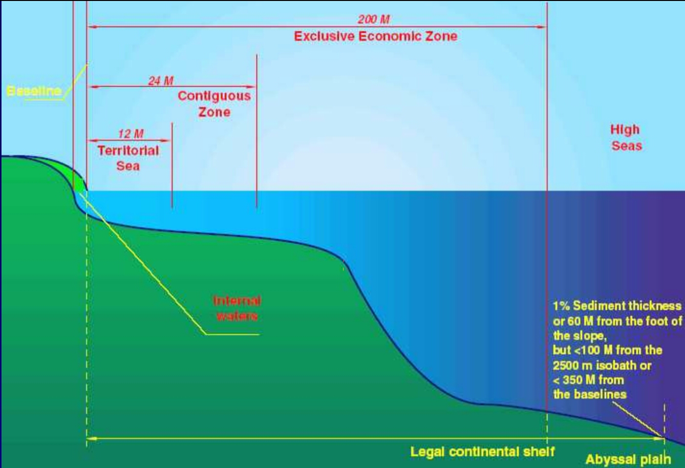
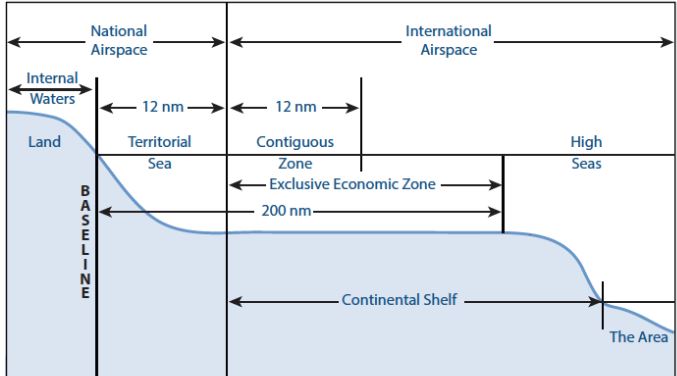
Maritime Zones
Baseline:
It is the low-water line along the coast as officially recognized by the coastal state.
Internal Waters:
Internal waters are waters on the landward side of the baseline from which the breadth of the territorial sea is measured.
Each coastal state has full sovereignty over its internal waters as like its land territory. Examples of internal waters include bays, ports, inlets, rivers and even lakes that are connected to the sea.
There is no right of innocent passage through internal waters.
The innocent passage refers to the passing through the waters which are not prejudicial to peace and security. However, the nations have the right to suspend the same.
Territorial Sea:
The territorial sea extends seaward up to 12 nautical miles (nm) from its baselines.
A nautical mile is based on the circumference of the earth and is equal to one minute of latitude. It is slightly more than a land measured mile (1 nautical mile = 1.1508 land miles or 1.85 km).
The coastal states have sovereignty and jurisdiction over the territorial sea. These rights extend not only on the surface but also to the seabed, subsoil, and even airspace.
But the coastal states’ rights are limited by the innocent passage through the territorial sea.
Contiguous Zone:
The contiguous zone extends seaward up to 24 nm from its baselines.
It is an intermediary zone between the territorial sea and the high seas.
The coastal state has the right to both prevent and punish infringement of fiscal, immigration, sanitary, and customs laws within its territory and territorial sea.
Unlike the territorial sea, the contiguous zone only gives jurisdiction to a state on the ocean’s surface and floor. It does not provide air and space rights.
Exclusive Economic Zone (EEZ):
Each coastal State may claim an EEZ beyond and adjacent to its territorial sea that extends seaward up to 200 nm from its baselines.
Within its EEZ, a coastal state has:
Sovereign rights for the purpose of exploring, exploiting, conserving and managing natural resources, whether living or nonliving, of the seabed and subsoil.
Rights to carry out activities like the production of energy from the water, currents and wind.
Unlike the territorial sea and the contiguous zone, the EEZ only allows for the above-mentioned resource rights. It does not give a coastal state the right to prohibit or limit freedom of navigation or overflight, subject to very limited exceptions.
High Seas:
The ocean surface and the water column beyond the EEZ are referred to as the high seas.
It is considered as “the common heritage of all mankind” and is beyond any national jurisdiction.
States can conduct activities in these areas as long as they are for peaceful purposes, such as transit, marine science, and undersea exploration.
 LIVE Online Class